


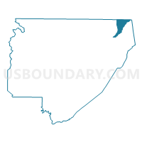
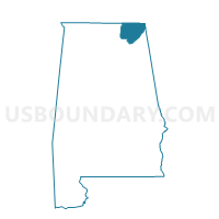
Long Island Community Center, Jackson County, Alabama
About
Outline

Summary
| Unique Area Identifier | 521956 |
| Name | Long Island Community Center |
| County | Jackson County |
| State | Alabama |
| Area (square miles) | 12.56 |
| Land Area (square miles) | 12.00 |
| Water Area (square miles) | 0.56 |
| % of Land Area | 95.55 |
| % of Water Area | 4.45 |
| Latitude of the Internal Point | 34.95745970 |
| Longtitude of the Internal Point | -85.67666380 |
Maps

Graphs
Select a template below for downloading or customizing gragh for Long Island Community Center, Jackson County, Alabama


Neighbors
Neighoring Voting District (by Name) Neighboring Voting District on the Map
- Bridgeport Community Center, Jackson County, AL
- Bryant School, Jackson County, AL
- New Hope Voting District, Marion County, TN
- South Pittsburg Voting District, Marion County, TN
- Stevenson City Park, Jackson County, AL
Top 10 Neighboring County Subdivision (by Population) Neighboring County Subdivision on the Map
- Long Island CCD, Jackson County, AL (6,749)
- District 1, Marion County, TN (5,323)
- Bridgeport CCD, Jackson County, AL (3,516)
Top 10 Neighboring Place (by Population) Neighboring Place on the Map
Top 10 Neighboring Unified School District (by Population) Neighboring Unified School District on the Map
Top 10 Neighboring State Legislative District Lower Chamber (by Population) Neighboring State Legislative District Lower Chamber on the Map
Top 10 Neighboring State Legislative District Upper Chamber (by Population) Neighboring State Legislative District Upper Chamber on the Map
Top 10 Neighboring 111th Congressional District (by Population) Neighboring 111th Congressional District on the Map
Top 10 Neighboring Census Tract (by Population) Neighboring Census Tract on the Map
- Census Tract 9501, Jackson County, AL (6,749)
- Census Tract 503.01, Marion County, TN (5,503)
- Census Tract 9502, Jackson County, AL (3,516)